
 © Fraunhofer IWES
Offshore Wind Energy
Surface-based system detects subsea cables
Gino Frielinghaus Mission Electricity
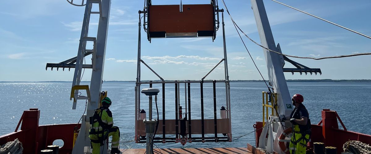
A new measurement system developed by Fraunhofer IWES and the University of Bremen can locate existing subsea cables and other objects on the seabed, map subsurface structures, and monitor installed infrastructure – all from the water surface. The technology is based on advanced seismo-acoustic imaging methods. The SASACD project initially focused on detecting and localising subsea cables. Gino Frielinghaus, Head of the Offshore Wind Energy business field at Fraunhofer IWES, outlines the system’s capabilities and potential applications.
Mr Frielinghaus, what was the starting point for your project?
We had already completed a highly successful predecessor project called "Boulder Detection". In that project, we developed the core principles and methodology for detecting objects in the subsurface, and generated patents and substantial technical expertise. Fraunhofer IWES then brought the technology to market, where it has since become well established and widely used.
The obvious next step was to ask: what else can this methodology do? Which other types of objects can we detect beneath the seabed, beyond so-called boulders – in other words, large stones or glacial erratics? Cable detection became one of the key follow-up applications.
What questions can your technology answer in relation to cable detection?
The first is whether a cable has been installed correctly. From a site investigation perspective, we also need to understand the subsurface conditions: what does the seabed look like, and how should the cable be laid to ensure optimal performance?
Cables are buried for two main reasons. One is cooling: a cable operates efficiently only if the heat it generates can be effectively dissipated into the surrounding sediment. The other is protection, particularly from external impacts such as shipping traffic.
Why is it important to know where offshore cables are located?
One reason relates to planning wind farm developments, especially where new cables are to be installed. Another concerns site investigations more broadly. Some cables and cable routes were not adequately documented in the past, for example in the 1980s, during the early days of offshore wind, or in the case of fibre-optic telecommunications cables.
Before developing a wind farm, operators need to carry out a comprehensive risk assessment to determine whether cables are already present in the area. In addition, cables can shift over time due to currents and sedimentation processes. In some cases, monitoring is now mandatory. Operators must verify that a cable remains in its original position or report any displacement.
What are the challenges in locating cables?
Existing methods, particularly magnetic techniques, have not been sufficiently precise and are prone to error. There are inherent geophysical uncertainties, as well as positioning challenges, because survey systems must operate very close to the seabed.
Acoustic methods offer a promising alternative. When the SASACD research project began, no suitable solutions were available. Since then, other companies have pursued similar objectives, in some cases using higher-frequency technologies based on signal reflections.
In the final phase of SASACD, we therefore shifted our focus towards developing a system capable of addressing a broad range of georisks within a single platform: object detection, cable detection, legacy hazards, site investigation and even archaeological surveys. The system is towed from the surface and designed to achieve deeper penetration into the sediment, although further research is still needed in this area. Ultimately, the goal is greater efficiency.
How did you approach the project, and what were the main challenges?
We work closely with industry partners and respond directly to practical questions raised by them. Our objective was to detect cable routes in real time with significantly improved accuracy, and to do so from the surface wherever possible.
The system is designed to cover the full spectrum of survey requirements for wind farm development. We can begin along the cable corridor, proceed to the wind farm site and assess individual turbine locations. In this way, we address georisks and monitoring requirements within a single campaign. Offshore time is extremely costly, so the ability to answer multiple questions in one survey run represents a major advantage. That is where we see the real potential of our approach.
Is there already interest from industry in using the system?
Yes, both cable manufacturers and grid operators have shown interest. For both groups, the site investigation aspect is particularly relevant. A central question is how efficiently a cable can be installed. Cable-laying operations are extremely expensive, and one of the worst-case scenarios is discovering that the purchased cable is too short because the actual route is longer than anticipated. Rectifying that situation is complex and costly.
As a precaution, developers often purchase additional cable length, which significantly increases costs. Certification is another key issue. In Europe in particular, companies must demonstrate that cables have been buried to the required depth. Existing methods do not provide sufficient accuracy. In simple terms, companies can either rely on this technology – or measure it manually.
How will the system support the expansion of wind energy?
It improves efficiency, creates synergies and combines multiple pre-investigation tasks within a single process. A crucial factor is the availability of data in real time. The timeframe for early-stage site investigations is typically very limited, as funding is still constrained at that stage. By delivering faster and more comprehensive results, our technology can help accelerate the expansion of offshore wind energy.
The interview was conducted by Leona Niemeyer, science journalist at Projektträger Jülich. Edited by Meike Bierther.


 and smaller climate cabinets, offers testing capabilities for entire converters and individual electronic components.")


 in the energy research programme.")